


Black Elk Peak: Hiking South Dakota's Highest Summit
- Stephen Warner
- Dec 9, 2023
- 5 min read
Updated: Apr 3

Located in Custer State Park, South Dakota’s highest peak offers a great challenge that’s still accessible for a wide range of hikers. With steady elevation gain, sweeping views, and a chance to scramble if you’re up for it, this hike gives you just the right balance of effort and reward. And when you’re standing atop the Black Hills, you’ll know it was worth every step.
Trail Info
Trailhead Name | Black Elk Peak |
Distance | 8.4 miles / 13.5 km (out and back) |
Estimated time | 3-5 hours |
Elevation gain | 1,700 ft / 520 m |
Highest point | 7,241 ft / 2,200 m (Black Elk Peak) |
Permits / fees | Custer State Park Day Pass |
Parking | Paved lot |
Toilets? | Yes |
Dog friendly? | Yes |
Know before you go
There are multiple ways to reach the summit. Most people do a loop—up Trail #9, down Trail #4 (or vice versa). According to Travel South Dakota, there are nearly a dozen route options. This post covers the clockwise route with a side trip to Little Devil’s Tower.
Custer State Park is busy, especially in summer and on weekends. Arrive early or go midweek to avoid the crowds.
The trail is open year-round, but the best time to hike is May through October. Outside those months, snow or ice may be present—microspikes may be needed.
Little Devil’s Tower is a great optional add-on with stellar views of Black Elk Peak and the Black Hills. It’s more technical than Black Elk, with steep scrambles and some hands-on climbing. It’s about and additional 0.8 mi / 1.3 km with 300 ft / 90 m of gain.
Other hikes nearby
Distance: 1.4 miles (2.3 km)
Elevation gain: Negligible
Details: A pleasant walk around the lake with almost no elevation gain, but still gives you a nice taste of the features of the park.
Distance: 1.7 miles (2.7 km)
Elevation gain: 500 ft (150 m)
Details: Located slightly away from the main parking area, this is a short hike to these aptly named rock features.
Details: 3.6 miles (5.8 km)
Elevation gain: 780 ft (240 m)
Details: Direct route to Little Devil's Tower that still features epic scenery and views. You will still have to do that scrambling though!
Trail 9 to Black Elk Peak

After paying your $20 day use fee and parking, you will head towards Black Elk PeaAfter paying your $20 day-use fee and parking, head toward Trail #9, marked by this sign. This is the start of your adventure.

The elevation gain starts off gently, offering a nice warmup before the steeper push later on. I was impressed by how well-maintained the trail was. It was wide, clear, and free of big rocks that could trip you up. Big shoutout to South Dakota trail crews

Even early on, the views start rolling in. Flasher’s Point, less than a mile in, makes for a great photo stop.

From there, the trail winds through the forest, climbing gradually. At about 2.7 miles / 4.3 km in, you’ll reach a major junction. Head left toward Black Elk Peak. (Note: if you’re doing this as a loop, you’ll come back here and go right on the descent.)

After this junction, things start to ramp up. The steps get a little taller and the incline steeper. If you’re coming from sea level, this is where you’ll feel it.

Around the 3-mile / 4.8-km mark, there’s another junction. Stay alert—left leads to the summit. It’s easy to miss if you’re zoned out (like I did).

One more split: veer left again to stay on the hiking trail (unless, of course, you brought a stock of bighorn sheep...)..

And now, you’ll finally spot your destination. That stone tower up on the rocks is the summit.

To reach it, you’ll climb a series of stairs carved through the rocks. The manmade parts of this trail do take away a bit of the “wild” feel, but it’s still cool
And definitely still beautiful.

Just a bit farther...

You made it! From the top, you’ll get panoramic views of the Black Hills. The mix of rock and dense forest is something I hadn’t seen anywhere else. We lingered here a while, soaking it all in, snapping pics, and feeling the full satisfaction of the summit.
Little Devil's Tower Trail

But don’t head back just yet, there’s more! After returning to the previous junction, follow the left trail toward Little Devil’s Tower.

On the descent, you’ll hit several trail splits. Always stay to the right to remain on the correct path. Other routes here lead into remote parts of the Black Elk Wilderness.

I really loved this section of trail. The foliage was thinner, which opened up more views. Plus, being closer to the rock formations gave a better sense of scale.

You’ll even catch a glimpse of the Cathedral Spires. There’s a side trail here too if you want a closer look and are down to tack on a bit more distance.

Soon, you’ll spot a sign for Little Devil’s Tower, less official-looking, but clear. The trail is well marked and easy to follow.
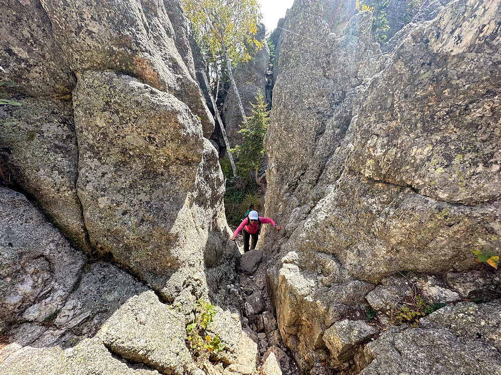
That said, it’s definitely more demanding. You’ll need to scramble quite a bit to reach the top.

Follow the blue arrows and paint markers to stay on the best path. I found this section near the tree to be the trickiest. It was steep with few footholds, but the rock was grippy and manageable with a bit of focus.

And you’re there! Look off into the distance—that’s Black Elk Peak. Can you believe you hiked all the way from there?
After soaking in those final views, retrace your steps to Trail #9. Veer right past a parking lot, then right again at the next fork, and you’ll return to Sylvan Lake

Conquering the highest peak in South Dakota and scrambling up Little Devil’s Tower? That’s what I call a great day of hiking.
SS Reflections
There’s something satisfying about hitting the “highest point” in a state. Black Elk delivers on all fronts. You can’t drive to the top, so you’ve got to earn it—but it won’t totally wreck you like some of the big western peaks. And of course you are rewarded with some killer views.
Still, my hot take? Little Devil’s Tower is the better trail. There’s something extra fun about a little scrambling, a little adrenaline, and working your way up to an epic view. However you explore this area, you’ll leave with a smile.
🎥 Little Devil's Tower Final Approach & Summit POV
Want another perspective? Check out this short of the final approach and summit of Little Devil's Tower!
Other Resources
Travel South Dakota's writeup of all the different routes to this summit
We're in the Rockies post about this hike.